 You
will be taken to the Timpohon Gate, the entrance to the summit trail where you
will start the climb. The forest on the steep ridge opposite the Power Station
is the montane oak-forest that surrounds the Park Headquarters and has some of
the richest oak forests in the world with over 40 different oak species
recorded. Here the Summit Trail itself starts, marked at intervals of 5 chains
(50 chains = 1 km.; 80 chains = 1 mile), leading past the Power Station and
following the crest of a narrow ridge that dips down onto the main slopes of
Kinabalu itself. A little further on, there is a waterfall where waterbottles
can be filled. This is known as Carson's Falls, named after the first Warden
of this Park. Liverworts and mosses grow luxuriantly in the fine spray of
water. A Common moss is Dawsonia, one of the largest in the world, that can
reach 3ft (1 m) in height. though it is usually much less. Nearby the KINABALU
BALSAM (Impatiensplatyphylla) can usually be found, a delicate little herb
growing in between rocks at the edge of the path. Rhododendrons are now more
common - the SLENDER- LEAVED RHODODENDRON (Rhododendron stenophyllum) is a
lovely sight in bloom. You
will be taken to the Timpohon Gate, the entrance to the summit trail where you
will start the climb. The forest on the steep ridge opposite the Power Station
is the montane oak-forest that surrounds the Park Headquarters and has some of
the richest oak forests in the world with over 40 different oak species
recorded. Here the Summit Trail itself starts, marked at intervals of 5 chains
(50 chains = 1 km.; 80 chains = 1 mile), leading past the Power Station and
following the crest of a narrow ridge that dips down onto the main slopes of
Kinabalu itself. A little further on, there is a waterfall where waterbottles
can be filled. This is known as Carson's Falls, named after the first Warden
of this Park. Liverworts and mosses grow luxuriantly in the fine spray of
water. A Common moss is Dawsonia, one of the largest in the world, that can
reach 3ft (1 m) in height. though it is usually much less. Nearby the KINABALU
BALSAM (Impatiensplatyphylla) can usually be found, a delicate little herb
growing in between rocks at the edge of the path. Rhododendrons are now more
common - the SLENDER- LEAVED RHODODENDRON (Rhododendron stenophyllum) is a
lovely sight in bloom.
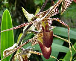
The SMALL MOUNTAlN PlTCHERPLANT (Nepenthes tentaculata) can also be seen by
the Sharp-eyed observer grows along the edges of paths, from the Headquarters
to as high as 2,439m (8,000ft).
 Beyond
Carson's Falls the trail starts to climb. Soon the path climbs steeply up a
series of steps formed out of tree-roots to reach the ridge at 1,951 m
(6,400ft). Here is the First Summit Trail Shelter where one can stop. This is
a good place to rest, and look back down the road that links the Park with the
town of Kota Kinabalu on the West Coast. The Mossy or Cloud Forest Zone starts
around this altitude. Tree-trunks are gnarled and twisted and their branches
loaded down with mosses, epiphytic ferns and orchids. Beyond
Carson's Falls the trail starts to climb. Soon the path climbs steeply up a
series of steps formed out of tree-roots to reach the ridge at 1,951 m
(6,400ft). Here is the First Summit Trail Shelter where one can stop. This is
a good place to rest, and look back down the road that links the Park with the
town of Kota Kinabalu on the West Coast. The Mossy or Cloud Forest Zone starts
around this altitude. Tree-trunks are gnarled and twisted and their branches
loaded down with mosses, epiphytic ferns and orchids.
At about 2,134m (7,000ft), the Second Shelter is passed, after which the path
climbs a steep narrow ridge, and, for a shorttime, comes out above the tree
canopy, before the ridge broadens again and the path widens as it dips back
into mossy forest. This is the zone of LOW'S PlTCHER-PLANT (Nepenthes lowii),
named after Sir Hugh Low, a British Colonial Officer who, In 1851, became the
first person to record his ascent of the mountain.
The mossy forest continues on past Kamborongoh Telecoms Station at 2,225m
(7,300ft), where a narrow track leads Up to the transmitters on the left. The
name is derived from a plant locally called 'kamborongoh', in the Dusun
language. that is used to ward off evil spirits. The site is a restricted
entrance area. On the right the Summit Trail continues along the side of the
ridge past an old landslide and up onto the ridge itself to the Third Trail
Shelter. The Summit Trail continues on the right, through the bamboo forest
where Miss Gibbs's Bamboo (Bambusa gibbsiae), a tall- climbing, delicate
plant, drapes the trees like moss.
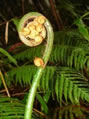 Tree-ferns
of several species are common. Look out here for little birds flitting or
creeping through the bamboos and ferns. Perhaps two of the easiest to identify
are the YELLOW- BREASTED WARBLER (Seicercus montis), Tree-ferns
of several species are common. Look out here for little birds flitting or
creeping through the bamboos and ferns. Perhaps two of the easiest to identify
are the YELLOW- BREASTED WARBLER (Seicercus montis),
and the MOUNTAlN BUSH WARBLER (Cettia montanus).the KlNABALU FRIENDLY WARBLER
(Bradypterus accentor), that is found only on Sabah's highest mountains.
Another birth that can be seen here is the PALE-FACED BULBUL(Pycnonotus
flavescensl. Soon after leaving the bamboo forest and the Fourth Shelter is
reached at 2,651m (8,700ft). This is a small clearing on the ridge crest with
an abandoned hut where wild raspberries (Rubus lineatus) grow in profusion. It
is a good place to stop and have lunch and relax in the cool mountain air. At
about 2,438m (8,000ft) one first sees LOW'S RHODODENDRON (Rhododendron lowii),
with magnificent heads of large peachy-yellow blooms, up to 30cm (12") across.
 From
Here the trail climbs steeply over an out-crop of ultrabasic rocks. These
rocks give rise to a distinctive yellow. almost orange-coloured soil
containing an unusually high concentration of toxic elements such as nickel or
chromium Only plants that have adapted to tolerate these elements will
survive. Consequently, the vegetation changes abruptly as the LEPTOSPERMUM or
TEA-TREE (Leptospermum recurvum), locally called 'sayat-sayat', a shrubby tree
with From
Here the trail climbs steeply over an out-crop of ultrabasic rocks. These
rocks give rise to a distinctive yellow. almost orange-coloured soil
containing an unusually high concentration of toxic elements such as nickel or
chromium Only plants that have adapted to tolerate these elements will
survive. Consequently, the vegetation changes abruptly as the LEPTOSPERMUM or
TEA-TREE (Leptospermum recurvum), locally called 'sayat-sayat', a shrubby tree
with
 small
greyish leaves and starry White flowers; and the Southern Pine (Dacrydium
gibbsiae), one of the southern hemisphere conifers, become the most abundant
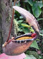
trees. The large and ornate MOSSY PITCHER- PLANT (Nepenthes villosa), up to
25cm (10") long is fairly common in this locality by the side of the trail.
The delightful little green MOUNTAlN BLACKEYE (Chlorocharis emiliae), with a
distinctive black eye can often be seen in this area and as far up as 3,810m
(12,500ft) dipping its beak into the rhododendrons and other flowers. small
greyish leaves and starry White flowers; and the Southern Pine (Dacrydium
gibbsiae), one of the southern hemisphere conifers, become the most abundant
trees. The large and ornate MOSSY PITCHER- PLANT (Nepenthes villosa), up to
25cm (10") long is fairly common in this locality by the side of the trail.
The delightful little green MOUNTAlN BLACKEYE (Chlorocharis emiliae), with a
distinctive black eye can often be seen in this area and as far up as 3,810m
(12,500ft) dipping its beak into the rhododendrons and other flowers.
Just before the Fifth Trail Shelter at 2,896m (9,500 ft) one climbs over the
first rock outcroppings, to a view looking back down the mountain towards the
Park Headquarters. On a clear day, glimpses of Kinabalu's jagged peaks,
towering far above, can be seen through the trees ahead. From the Fifth
Shelter the path follows a gully with orchids and rhododendrons in abundance
Ten minutes walk further on brings you off the ultrabasic soil and to the
Sixth Trail Shelter at 3,109m (10,200ft)
The Paka Cave, really a large overhanging rock by a swift-flowing rocky
stream, is situated near here on a slight detour to the left of the main
trail. This 'cave' was where the first explorers used to spend the night
before climbing to the summit the next day. Large areas of granite rock soon
begin to appear and at about 3,353m (11,000ft), the edge of the tree-line.
Panar Laban is reached.
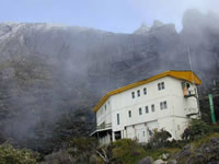 Most
people stay overnight here at the Laban Rata Resthouse where electricity, hot
water, room heaters and a canteen are available, before climbing to the summit
the next morning. The name Panar Laban is derived from a corruption of the
Dusun word meaning 'Place of Sacrifice'. Here the first explorers stopped to
sacrifice a white cockerel and seven eggs to appease the mountain spirits.
Today, the sacrifice is still carried out once a year. There are also three
other mountain huts in this area with more basic facilities Most
people stay overnight here at the Laban Rata Resthouse where electricity, hot
water, room heaters and a canteen are available, before climbing to the summit
the next morning. The name Panar Laban is derived from a corruption of the
Dusun word meaning 'Place of Sacrifice'. Here the first explorers stopped to
sacrifice a white cockerel and seven eggs to appease the mountain spirits.
Today, the sacrifice is still carried out once a year. There are also three
other mountain huts in this area with more basic facilities
If you are climbing to the summit - a word of warning. Mountains should be
treated with respect and you climb Kinabalu at your own risk, The weather can
change very quickly from brilliant sunshine, to mist and clouds, to a
torrential down-pour. The nights at Panar Laban and Sayat-Sayat are cold and
temperatures can drop to below freezing. Ensure you bring enough warm clothes
with you and pack them in plastic bags to keep dry. Park Regulations require
that all climbers to the summit are accompanied by a registered guide.
 From
Panar Laban onwards the vegetation is stunted and scrublike except in the
gullies, and there are superb views of the great granite peaks soaring high
above. Leptospermum and the Heath Rhododendron are abundant and occur almost
all the way to tbe summit. In open ground below the granite slopes small
alpine meadow plants can be found. The white-flowered BORNEO EYEBRIGHT (Euphrasia
borneensis) and the pinkish-white MOUNTAlN TRACHYMENE (Trachymene
saniculifolia) are common. The most conspicuous creature at these a altitudes
is the BORNEAN MOUNTAIN GROUND SQUlRREL (Dremomys everettii) which is often
seen scampering about in the scrubby vegetation. The KlNABALU RAT (Rattus
baluensis) is another well-known species which is found only on the mountain. From
Panar Laban onwards the vegetation is stunted and scrublike except in the
gullies, and there are superb views of the great granite peaks soaring high
above. Leptospermum and the Heath Rhododendron are abundant and occur almost
all the way to tbe summit. In open ground below the granite slopes small
alpine meadow plants can be found. The white-flowered BORNEO EYEBRIGHT (Euphrasia
borneensis) and the pinkish-white MOUNTAlN TRACHYMENE (Trachymene
saniculifolia) are common. The most conspicuous creature at these a altitudes
is the BORNEAN MOUNTAIN GROUND SQUlRREL (Dremomys everettii) which is often
seen scampering about in the scrubby vegetation. The KlNABALU RAT (Rattus
baluensis) is another well-known species which is found only on the mountain.
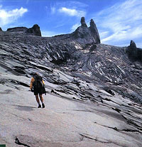
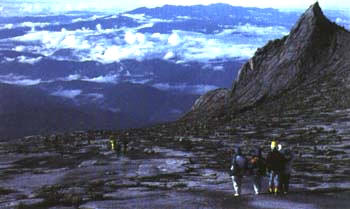
From Panar Laban the path follows another gully up to Sayat-Sayat, named after
the abundant 'sayat-sayat' or Leptospermum bushes. Beyond Sayat-Sayat begins
the Summit Plateau itself - a vast expanse of grey granitic slopes. Granite is
a rock composed of various minerals which differ in their resistance to
erosion and weathering. The result is a distinctive rough pitted surface.
speckled with white, grey and black. Cairns mark the trail that leads slowly
upwards between South Peak and St. John's Peak on the left and the Donkey's
Ears and the Ugly Sisters on the right. The Summit itself. Low's Peak, is not
visible until the upper part of the Summit Plateau is reached.
 Any
plants on the Plateau are reduced to clinging to cracks in the rocks. Few
birds are seen up here but there are magnificent views, especially of the
awesome cliffs of Low's Gully, a 1 1/4 km (1 mile) deep cleft that divides the
east and west arms of the mountain. Most people climb to the summit in time to
see the sunrise and dawn creep slowly over the land, illuminating the
coast-line west and north and the dim ranges of hills to the south. Any
plants on the Plateau are reduced to clinging to cracks in the rocks. Few
birds are seen up here but there are magnificent views, especially of the
awesome cliffs of Low's Gully, a 1 1/4 km (1 mile) deep cleft that divides the
east and west arms of the mountain. Most people climb to the summit in time to
see the sunrise and dawn creep slowly over the land, illuminating the
coast-line west and north and the dim ranges of hills to the south.
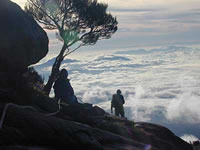
In good weather almost all of Sabah can be seen before the clouds come up
(usually around 9.00 or 10.00 am) and it is time to begin the descent.
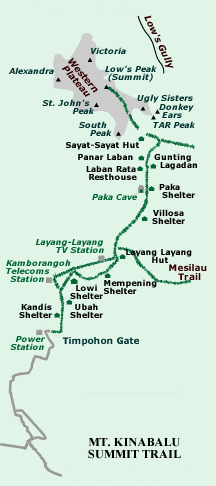
Average walk time to the various mountain
hut stopping points
|
Park headquarters to Power Station |
I Hour |
|
Power Station to Kambarangoh Station |
1 � Hours |
|
Kambarangoh Station to Layang-Layang Station |
1 � Hours |
|
Layang-Layang Station to Paka Cave |
1 � Hours |
|
Paka Cave to Panar Laban |
1 � Hours |
|
Panar Laban to Sayat Sayat |
1 � Hours |
|
Sayat Sayat to Low's Peak |
2 � Hours |
RELATED LINKS
Kinabalu Park - Mount Kinabalu
The highest mountain between the Himalayas and New Guinea - The mountain, Park
regulations, mountain trail and climb, the accommodations and the best time to
go
Kinabalu Park
Designated a World Heritage Site by UNESCO as one of the most
important biological sites in the world and as the keeper of the treasures of
Mt Kinabalu, Kinabalu Park showcases an eco-system unrivalled anywhere else in
the world.
|
|