� Pulau Gaya � Pulau
Sapi � Pulau Manukan � Pulau Mamutik � Pulau Sulug �
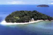
Lying just 3 to 8
kilometers off the coast off Kota Kinabalu, The Tunku Abdul Rahman Park covers
an area of 49 square kilometers comprises of 5 islands surrounded by coral
reefs and sea. The islands are Pulau Gaya, Pulau Manukan, Pulau Mamutik, Pulau
Sapi and Pulau Sulug.
Pulau
Gaya / Gaya Island
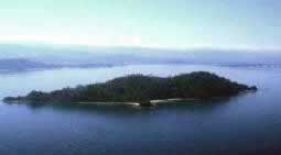
Pulau Gaya is the largest island of the park, and occupies an area of 15
square. Its name is derived from the Bajau word "Gayo" which means big.
Covered with dense virgin tropical forest, it several ridges, rising more than
600 feet (180 m) and peaking at 1,000 feet (300 m), form the backbone of Pulau
Gaya.
Being the closest island to Kota Kinabalu, it has a Marine Ecology Research
Centre, hiking trails and some resorts. However it also has a a very large
(and growing) stilt village occupied by illegal immigrants from the
Philippines and is considered a dangerous high crime and a "stay-away" area by
the police and KK locals.
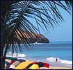
The major beach area in Gaya located at the Police Bay, a quarter mile of
white sand gently slopes out to the sea makes Police Beach ideal for swimming
in the crystal clear water. The coral reefs along the entire coast of island
are in excellent condition. There is also a plank walk which has been laid
across an inlet of mangrove trees to allow visitors a closer look at the
botanical curiosities and their adaptations to a watery existence.
There is also another
Pulau Gaya in Sabah and is known as the Gaya Island group and is located off
the states Eastern coast
 Pulau
Sapi / Sapi Island Pulau
Sapi / Sapi Island
Located just off the south-western tip of Pulau Gaya, a sand-bar connects Sapi
Island to the larger island and it is possible to walk across in shallow water
at very low tides. The 25 acre (10 ha) island features one of the nicest
beaches in the park and most popular for snorkeling and scuba diving. There
are no overnight facilities available but It is developed with tourist
facilities that includes a jetty, picnic shelters, barbecue pits, tables,
changing rooms and toilets. The forest is inhabited by long tailed macaque
monkeys
and wandering monitor lizards.
 Pulau
Manukan / Manukan Island Pulau
Manukan / Manukan Island
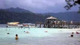
Manukan is the second largest island and the most popular. Out of 5 islands,
Manukan features the most developed tourist facilities that includes 20 units
of chalets, a clubhouse, and few restaurants and a dive centre. Recreation
facilities include a swimming pool, football field, squash and tennis courts.
It is covered in dense vegetation and has hiking trails and some good
stretches of beaches on the southern coastline with the best being on the
eastern tip of the island. Manukan also has coral reefs, which is ideal for
snorkelling, diving and swimming. Snorkelling is the best at the eastern part
the island.
Pulau Mamutik
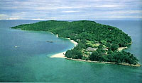
The 15 acres island makes Mamutik the smallest island in the park. Despite
being the smallest, the island offers some good beaches and coral reefs. It
also has a jetty, a 3 bedroom resthouse for rent, with facilities that include
changing rooms, toilets, picnic shelters, tables and barbecue pits. Fresh
water and electricity are also available.
Pulau Sulug
Sulug is the farthest island of them all. Considered relatively untouched,
remote and undeveloped, the 20-acre (16 ha) island is more popular with those
who prefer a quiet and tranquil atmosphere. Good reef patches lie along the
southern end of the island.
RELATED LINKS
Tunku Abdul
Rahman Marine Park
An introduction the the park, with map, description and
staying there.
TAR Marine Park ~ Diving
Info on Diving in TAR Marine Park, description of Dive
sites and map
|
|