|
� Gunung Mat Cincang � Gondwana Mountain � Telaga Tujuh � Datai Beach �
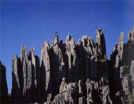
Gunung Mat Cincang - A Walk in the
Clouds
The legendary Gunung Mat Cincang, Langkawi's second highest peak was
believed to have been once a being named Mat Cincang who turned himself into
a mountain. Fables aside, today the mountain rises in a spectacular skyline
of crags that glow pink in the sunset and is part of the Mat Cincang Range
which comprises of some of the oldest rock formations in Malaysia, dated
about 2,400 million years old
Take a walk above the clouds on the new pedestrian bridge at Gunung Mat
Cincang. Suspended at 700 metres above sea level the unique curved
pedestrian bridge spans 125 metres across a scary chasm.

Views are spectacular, offering a panorama over the landscape, the Andaman
Sea, offshore islands and beyond to neighbouring Thailand. Unlike straight
bridges where you can see from the starting point, the bridge has been
curved to provide different perspectives over the land and sea. Convenient
triangular platforms located along the curved bridge provide rest areas so
you can sit and appreciate both the beauty of nature and an incredible feat
of engineering.
Visit Rating

 Gondwana
Mountain Gondwana
Mountain
Gondwana is simply fascinating and differs from the other landscapes in
Langkawi. Joining up with Gunung Mat Cincang the steepness of this mountain
area shows how great the tectonic pressures can be.
In all of 23,000 islands in the South-East Asia, not one can pose a
challenge to the geological to the geological beauty of the Langkawi Islands
Location - Mountain area behind Teluk
Burau from Teluk Datai to Teluk Buta / Visit Rating
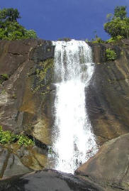
Telaga Tujuh (Seven Wells)
Visitors to Pantai Kok should travel two kilometres further north to see the
breathtaking Telaga Tujuh or "seven wells". The waterfall is so named
because its cascading water flows into the other creating the seven pools.
The swift flowing water has created smooth rock surfaces allowing the water
to flow from one pool to another; finally cascading 90 metres down into the
seventh pool. From the car park, you'll walk pass several tourist shops to
get to the entrance. After walking up for a short while, you'll see a sign
directing to 'Waterfall' on your left. It's not the Seven Wells but it's
worth a short visit. After this waterfall, walk back to the original path
and continue walking up for around 330 steps - you'll get to the Seven Wells
Waterfalls.
 The short climb to the top of the falls will take about 45 minutes through
the rainforest. You're likely to see long-tailed macaque monkeys and, if
you're lucky, the giant cream coloured squirrels or even catch a glimpse of
a hornbill, considered the most unique of all Malaysian birds. The short climb to the top of the falls will take about 45 minutes through
the rainforest. You're likely to see long-tailed macaque monkeys and, if
you're lucky, the giant cream coloured squirrels or even catch a glimpse of
a hornbill, considered the most unique of all Malaysian birds.
The water is cool and clear, ideal for swimming after the hike up. Starting
from the highest well you can slide down one by one through all these
shallow pools (the interconnecting stone channels are very smooth). The rich
green forest that surrounds the waterfall adds a mystical touch to the
splendour. Legend says that the waterfalls were so pretty that fairies were
unable to
resist its charm and made it their bathing place. Some of the plants growing
around the pools are said to have been left behind by them.
Note
* Remember to bring your swimsuits
* Beware of the slippery algae on the rocks
*Good walking shoe with good sole is recommended.
*Not recommended during the dry season where the water levels
would be too low to be of ant significance.
Location � Close to Datai / Visit Rating

Pantai Datai (Datai Beach)
Characterized by boulders at both ends of the beach and dense forest in the
background, Pantai Datai or Datai Beach, slopes gently into clear blue waters.
Facing the beach directly is the delightful little island of Pulau Anak
Datai.
Visit Rating

travel - visitors guide - sightseeing - places of interest |
|
